|
|
|
The sunlit pavilion
The setting sun brightens the pavilion atop Pawnee Rock State Park. Let's see your photos: Would you like to display your historical photos of Pawnee Rock and its people? Size them to about 600 pixels wide and e-mail them to leon@pawneerock.org. Tell us who and what are in the photo, when it was taken and so forth. Don't be shy -- it's OK to send photos of your relatives! They'll appear on our home page and then in the Pawnee Rock gallery. |
Too Long in the Wind
March 10: Norma Kasselman has died. Dog of the Afterworld Read Leon Unruh's novel about what happens when a Russian assassin comes to a town much like Pawnee Rock. Buy a paperback copy at Town Crier in Emporia, the Raven in Lawrence, Watermark Books in Wichita, Gulliver's Books in Fairbanks, the Book Shelf in Eagle River, or at Quincy Press. Also, a Kindle version is available. Read Leon Unruh's novel about what happens when a Russian assassin comes to a town much like Pawnee Rock. Buy a paperback copy at Town Crier in Emporia, the Raven in Lawrence, Watermark Books in Wichita, Gulliver's Books in Fairbanks, the Book Shelf in Eagle River, or at Quincy Press. Also, a Kindle version is available.
Pawnee Rock reunions, photos1950 Pawnee Chief yearbook1972 PRHS galleryFriends of Pawnee Rock Weather: Click on the box for the forecast.
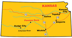 all about the town of Pawnee Rock, Kansas. Search our site
| ||||
|
Home | City | Things to do | Things to see | What's nearby | Churches | Gallery |